
Important Links:
- Bellevue Strong, Community Organization Site
- Ariza Bellevue, Developer’s Site
- Petition against new development in ‘flood-vulnerable’ area reaches 1,800 signatures (3/9/23: WSMV4)
- Bellevue development both raises concerns and garners praise (3/6/23: Fox17 Nashville)
UPDATE | February 2023: Harpeth Conservancy raised concerns about flood safety issues to planning staff and the Developers. In response, the Developers modified their flood study and proposed a potential solution to some of the safety concerns addressed below. To help prevent residents from being trapped on Coley Davis Road during flood events, the Developers propose elevating Coley Davis Road above the 500-year floodplain and the 2010 flood levels. Harpeth Conservancy will continue to monitor the Developer’s proposal to ensure the project does not negatively impact residential flood safety.
To voice your concerns, we encourage community members to send comments to planning.commissioners@nashville.gov. We encourage community members to attend the Metro Planning Commission Meeting discussing these issues from 4:00-7:00 PM on March 9, at the Howard Office Building. At the meeting, each citizen will have the opportunity to speak for 2 minutes. This is an excellent opportunity to express concerns.
—
Background
Harpeth Conservancy has been involved in flood recovery and floodplain management policy for many years. Our organization is a coalition member of Flood Ready TN. This coalition of elected officials, homeowners, small business owners, faith leaders, and community members across the state are dedicated to making Tennessee resilient against frequent flooding. Flood safety is of critical importance for developments along waterways especially during rezoning, plan amendments, and related land use decisions.
Metro has recently contracted with the Army Corp of Engineers to update river flow and rainfall statistics across Davidson County as part of an effort to incorporate the impact of climate change into flood risk modeling. Over the past several decades, the incidence of major rainfall events in the Middle Tennessee region have increased. Nowhere is that more clear than in Bellevue, where the 2021 flood was second in magnitude to only the 2010 flood a mere decade prior. The Army Corps’ work will be very valuable in evaluating any proposed changes to current zoning, transect policy, other aspects of Nashville Next and subdivision regulations. Nowhere will this effort be more clear than on the proposed development property.
Public Safety during Flooding is a Significant Concern with this Proposed Rezoning for an Apartment Complex:
The National Weather service, Turn Around, Don’t Drown campaign is very clear about floodwater risks. Six inches of water will reach the bottom of most passenger cars and cause loss of control and possibly stalling. A foot of water will float most vehicles. Two feet of moving water can carry away most vehicles including SUVs and pick-up trucks.
The cost of emergency response is not fully recovered from disasters and puts emergency personnel at risk as well as the risks the loss of or damage to equipment. During the March 28, 2021 flood Metro lost a million dollar plus fire truck when it was responding to a flood call. The flood waters on Old Harding from the Harpeth were deep enough that the fire truck lost the ability to control the truck and the team had to abandon it.
Flood fatalities are the second leading weather-related cause of death after heat. Flood fatalities are predominantly from people driving into floodwaters, especially at night. Ariza Bellevue developers have stated that “many residents in neighborhoods across the Nashville region would need to shelter in place” and that the Ariza buildings “will remain outside of the flood zone to provide refuge for our residents.” This response misses the fundamental issue with public safety during flooding- of all flood fatalities over the past 11 years (2010-2022), the largest activity victims were performing was “driving.”
During major flood events, Ariza Bellevue would leave 417 households surrounded by floodwaters. This increases the likelihood of people driving through floodwaters, straining emergency services and creating critical public safety risks.
Transportation Access to this Property Would Also Be Compromised by Major Flooding
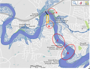
The proposed site of this project is compromised by floodwaters not just at the close proximity to the proposed development but further away as well! The map below indicate four areas where flood waters inundate roads that hamper both access to the property directly as well as emergency access and response. The maps and data of depth of water on Coley Davis and Morton Mill are provided by Barry Moran, Hydraulic Engineer, for the Nashville District of the Army Corp. He led the project for Metro to update the current adopted floodplain maps in this area after the 2010 Flood. This information is from the Metro GIS maps.
This map was prepared by Harpeth Conservancy to show the 4 areas constrained by floodwaters.
Here is drone video off Facebook from 2021 showing the flooding at Old Harding and Morton Mill where the fire truck was stranded. This is the way into the Morton Mill area, which is very constrained during flood events.

Flood Events Are Increasing; Flood Models Are Merely Estimates
Floodplain and floodway lines on maps mark probabilities, not permanent non-changing lines that floodwaters will not cross. Nashville is one of the country’s most at-risk inland cities for flooding. Severe storms are now more frequent and more intense. Rainstorms of 5 inches and higher have doubled in frequency in the Nashville area. In August 2021, the Waverly, TN catastrophic flood set a new state record of over 17 inches of rainfall. Computer models are not accounting for this changing weather intensity.
As noted above, this is the impetus for the work Metro has contracted the Army Corp to do in updating river flow statistics and to do predictions of flooding with large rain events hitting specific rivers systems in the county.
The March 2021 flood (7+ inches) is now the second largest storm event in this area since the historic May 2010 flood, only 11 years ago. The May 2010 flood was created from two back-to-back large storms for a total of nearly 14 inches of precipitation! The floodplain and stormwater models have a key assumption that there will be 72 hours, or a drying period of some standard length, between storms and rain events. When ground is saturated and rain events are frequent, the models under predict the volume of water and flood levels. Roger Lindsey, Metro Water Services staff, who is involved with the TN Floodplain Managers Association, provided a great overview with statistics at our May Conservation Conversation in 2021 on flooding.
There are several key statistics that are the foundation of floodplain and stormwater models– rainfall statistics and river flow statistics. Aaron Rogge, at CDMSmith, presented on the need to update rainfall statistics to the Franklin aldermen and planning commission about 1.5 years ago. He and other experts in the Army Corp, engineering consultant firms, and Metro staff point out that a key foundation of these models used for stormwater design and floodplain mapping are the rainfall statistics published by NOAA.
The NOAA tables are the rainfall statistics used for the “design storms” that are the basis of floodplain and stormwater design and regulations. These statistics were published in 2006, but go through 2004. This means the May 2010 flood, March 2021 flood, and the last 17 years of rainfall are not in the statistics. Aaron Rogge at CDMSmith provided us with outputs from their NetStorm link that runs the statistics and includes more recent data at the stations in Nashville used for the national statistics. Larger storm events (5 inches in 24 hours) are now more frequent, doubling in frequency. The March 28, 2021 flood that resulted from the 8.6 inch 24-hour storm event in Nashville now has a recurrence frequency that has doubled.
Recent extreme storms that created new historic record flooding in St. Louis and Eastern Kentucky in late July reinforce what experts in stormwater and floodplain management have been pointing out—extreme rain events likes these, March 2021, and May 2010 are now over 4 times more likely than they were 20 years ago.
New high density development needs to address current flood constraints for public safety and consider the May 2010 Flood
The May 2010 flood had a historic peak of 33.23 feet above the gauge at Highway 100. This is about 7 feet ABOVE the 500 year flood elevation on the Army Corp maps above. In light of this significant weather event, Harpeth Conservancy recommends that consideration of high density development on this site be delayed until updated flow stats, rainfall stats and floodplain models are completed. HC further recommends that development of the site only continue after Coley Davis Road is elevated above the 500-year floodplain, creating a safe means of ingress during flooding. “Shelter in place” is not an acceptable option.
The Current T2-RM Land Use Policy Is Best Suited to this Site
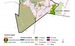
The Bellevue Community Plan, first adopted by the Planning Commission in 1990 and subsequently updated in 1996, 2003, and 2011, accurately reflects the desires of Bellevue area residents expressed over successive decades of many community meetings, the unique character of the Bellevue community, and the professional expertise of the Metro Planning Department. The Bellevue Community Plan’s application of Community Character Policies, “the standard by which development and investment decisions are reviewed,” was carefully considered and should not be unduly ignored.
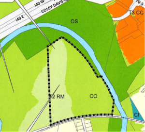
The application of T2 Rural Maintenance Policy to the property located at 1084 Morton Mill Road was not accidental. It’s because T2 Rural Maintenance is the most appropriate zoning for the subject property.
T2 Rural Maintenance Policy (“T2-RM”) is appropriate for areas “where the primary land use is rural residential, or that are envisioned to remain primarily rural residential.” T2-RM is “applied in situations where there is an expressed interest in maintaining the predominant, existing developed and undeveloped condition and that condition is believed to be stable and sustainable over time.” The desire of Bellevue residents, as expressed in the adopted Community Plan and in public comments opposing a policy change, indicate a desire to maintain an existing rural state- the very purpose of T2-RM Policy.
The unique geographic constraints of the Morton Mill property support the continued application of T2-RM Policy. Boundaries used to defined T2-RM areas include “environmental features” and “human-made features (rail lines, major utility easements, prominent roads).” The Morton Mill property fits this description: To the north, east, and west, the property is isolated by a narrow, artificial bend in the Harpeth River; along the southern boundary the property is bounded by CSX railroad tracks. Scenic River Farms, located southwest of the Morton Mill property in a similar bend of the Harpeth River, is also governed by T2-RM policy due to site constraints. Metro Planning’s application of T2-RM to these similar, nearly-adjacent properties was not coincidental but reflects reasoned consideration of the unique geographic constraints imposed by the Harpeth River.
A Community Plan Amendment to apply T3 Suburban Neighborhood Evolving Policy (“T3-NE”) to this property and allow higher-density development would be inappropriate. T3-NE areas are “undeveloped, underdeveloped… and are anticipated to be developed in suburban residential patterns.”
The geographic constraints of the subject property make anticipated suburban development on the site challenging without significant alterations.
Development of the property as proposed would not create a level of connectivity sufficient to meet T3 standards. T3-NE Connectivity guidelines call for “moderate” vehicular connectivity to “provide residents with multiple route options to destinations.” Currently, the Morton Mill property is accessible solely by a driveway including an unguarded crossing over the CSX right-of-way. The owner’s development plans for the site call for a single bridge to be constructed over the Harpeth River to the north, connecting the property to Coley Davis Road. This bridge access would be the sole means of ingress and egress for residents. (A grade crossing on Morton Mill Road would remain for emergency vehicles only.)

The road the Morton Mill property owners intend to connect via bridge, Coley Davis Road, terminates at the Harpeth River to the west. East of the proposed Morton Mill property bridge, Coley Davis has been submerged in as much as three feet of water in recent Nashville flood events. In those same flood events, Morton Mill Road, to be used for emergency access only, has also been submerged by floodwaters. Connectivity to the property, already low, could be fully eliminated during floods.

For the above reasons, Harpeth Conservancy encourages you to reach out to Metro Planning and voice your concerns! Comments can be sent to planning.commissioners@nashville.gov by 3:00PM on February 21st. We encourage you all to attend the Metro Planning Commission Meeting discussing these issues from 4:00-7:00 PM on February 23, at the Howard Office Building. At the meeting, each citizen will have the opportunity to speak for 2 minutes. This is an excellent opportunity to express concerns.