


This content has been archived. It may no longer be relevant
BIG SUCCESS: Franklin Mayor and Aldermen voted UNANIMOUSLY to DENY this Controversial Rezoning and Development Proposal Because of the Extensive Alteration of the Floodplain and Public Safety Risk from Flooding.
The community attendance was 200 or more, with over 50 speakers, for one of the longest City of Franklin meetings in recent memory (over 3 ½ hours).
Aldermen noted the thoughtful and personal emails from over 125 people as well as calls over the past 2 months. This made a huge impact. Please email them (see below for list) to thank them for their time to consider this controversial proposal carefully and work with the community on a more appropriate option. One that has large community support is to purchase the farm to create a public park that continues the horse show legacy and adds other community recreational needs.
Mayor Ken Moore in his remarks specifically talked about how flood risk is increasing as atmospheric rivers generate more intense storms. “No question that the Brownland Farm property is very difficult parcel to develop because of the floodplain and the circuitous route of the Harpeth River,” Franklin Mayor Ken Moore said. “This is a significant policy deviation and I’m concerned it has a long-term implication for our growth. We don’t have to develop every square inch of Franklin and we don’t have to shoehorn a project in a parcel, but rather we should make sure the land dictates what goes there.”
PRESS: Tennessean, Williamson Herald, Williamson Home Page, Williamson Source
Newschannel 5: Sunday when developer shows up a community rally, and Tuesday city Franklin vote to deny!
ACTION! The Brownland Farm rezoning and development proposal is now before the Board of Mayor and Aldermen for final votes! April 26, 7pm is the public hearing for both the rezoning and development plan. YOUR ATTENDANCE IS CRUCIAL!
Send your email by Monday, April 25, at noon, and contact the Franklin Mayor and Aldermen urging them to follow both the staff and Planning Commission recommendations to Deny the rezoning and development plan. Include recorder@franklintn.gov with your email list so your email is part of the record. (You can cut and paste the emails below. Phone numbers for each elected official are on the city web site link above.)
ATTEND the city meeting even if you do not want to speak. Your Presence Really Matters! Franklin City Hall: 109 3rd Ave South, Franklin, TN 37064
ken.moore@franklintn.gov; alderman.potts@franklintn.gov; clyde.barnhill@franklintn.gov; brandy.blanton@franklintn.gov; patrick.baggett@franklintn.gov; bev@aldermanburger.com; matt.brown@franklintn.gov; annpetersen@comcast.net; gabrielle.hanson@franklintn.gov; recorder@franklintn.gov
UPDATE: At the first vote (March 22) of 3 votes on the rezoning, the Franklin Board and Mayor and Aldermen voted to have the rezoning go to second reading and vote even though staff recommendation was to deny the rezoning at the first vote. (Press below). New Ward 2 Alderman Matt Brown stated: “There’s no benefit to the city, no infrastructure, no roads, we aren’t fixing flood issues anywhere else.”
See most recent important documents as of 4/20:
- Most recent staff memos explaining how rezoning can not be approved because it is NOT “consistent with Envision Franklin and the purposes of the Ordinance.” 1) deny rezoning, 2) deny development plan 3) staff map showing small amount of developable land on Brownland Farm
- letter from attorney clarifying misrepresentations by developer team regarding property owners of Site 1 landscaping- related to first emergency by-pass route for flooding.
- Email from city senior staff clarifying misrepresentations by developer team on raising Hillsboro Road and for latest emergency by-pass route for flooding.
The Franklin Planning Commission on Thursday, 2/24/2022, followed the staff recommendation and voted to recommend denial to the Franklin Board of Mayor and Aldermen. The votes were 6-2 to deny the rezoning and 7-1 to deny the development plan. These votes were much more decisive than in 2021. The staff and Planning Commission have recommended denial TWO Times now!
Op-ed in Tennessean: Franklin BOMA Should Reject Development Proposal on Brownland Farm, 4/18/2022 electronic. Forth coming in print.
Op-ed in Williamson Herald: Time to End Brownland Farm Saga, 4/20/2022.
Press story 3/27/2022- Need to Update Severe Storm Statistics for Floodplain changes: Tennessean. HC CEO and other floodplain management experts quoted.
Press on march 22, Franklin aldermen first vote on rezoning: Williamson Herald
Press on Planning Commission Feb 2022 vote: Home page, Williamson Herald
See press after the March 8 BOMA work session discussion. Public input is vital!
Brief Summary:
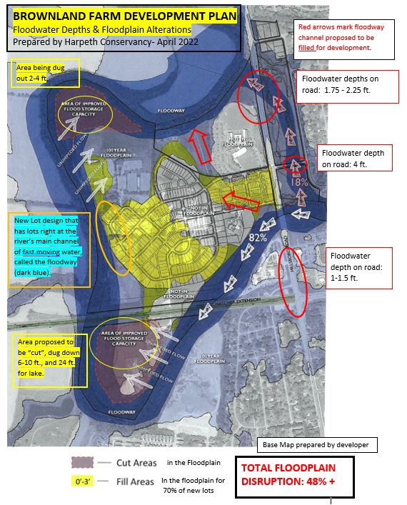
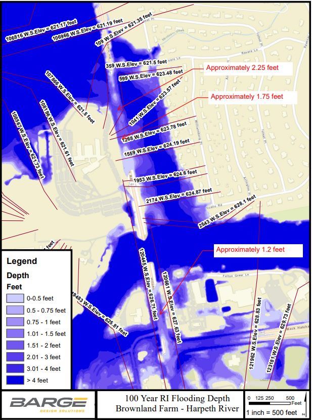
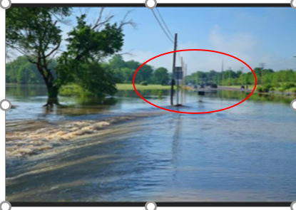
The proposed development is in a uniquely challenging bend in the Harpeth River because the high-density residential development proposal will be surrounded by floodwaters. As seen in the map from the city engineering consultant expert below, floodwaters cut across this bend and inundate Hillsboro Road to the north and south of the proposed development entrances cutting off all the ways in and out. Recent maps show that floodwaters are over 1 to 2.5 FEET over Hillsboro Road which is MUCH deeper than the city requirement for roads to have 3 inches or less over half the road during a 100-year flood event. This creates an important public safety risk! (details and maps below).
The development proposal involves altering about 50% or more of the property that is currently natural floodplain west of Hillsboro Road to maximize development without improving any of the flooding issues on Hillsboro Road to reduce safety risk. About 70% of the proposed residences are in the reshaped floodplain based on city staff review. The city staff have consistently recommended denial because the proposed development does not comply with the city’s Envision Franklin growth plan that states floodplain “disruption should be limited to preserve form and function.” Also the bulk of the development plan is NOT in the developable conservation subdivision use (see city staff map). The staff memo notes this would be the first since the adoption of Envision Franklin in 2017 that a rezoning and development proposal has not followed this.
Nor does the floodplain alteration proposed reduce flooding risks just downstream where large residential subdivisions (Fieldstone Farms and others) have over 450 homes now in the 100-floodplain that were not when approved over 20 years ago. This is very the most extensive floodplain alteration proposal the city of Franklin has seen in many years.
It would be much more appropriate to consider a different development concept that is NOT predominately residential to reduce flood safety concerns and consider how to reduce flood risk to adjacent residential areas now experiencing increased flooding. There is strong community interest in having Brownland Farm be purchased by the city to expand much needed recreational land especially to serve the horse riding communities, expand the Greenway along the Harpeth, and more.
Harpeth Conservancy email letter to Planning Commission- Feb 2022.
Staff reports recommending denial to BOMA on rezoning and recommending denial for Feb 2022 Planning Commission: rezoning and development plan.
Link to February 2022 Planning Commission agenda and material for rezoning (item 5) and development plan (item 6). These are the same documents before the Board (see work session agenda item 7 & 8)
Update from Franklin BOMA vote 8-0 at October 2021 meeting to Send Development Proposal Back Through Review and Approval Process:
At the final vote on the Brownland Farm development proposal in October 2021, the Mayor and Aldermen voted 8-0 to require the developer to essentially go back through the review and voting process. It was not a complete denial, but it was a clear message to the developer that BOMA and the staff were not going to consider last minute changes the developer presented the day of the October voting meeting. The developer had proposed 5 “conditions” in hopes of BOMA adopting them as part of a vote of approval. The 5 conditions are merely what the developer suggested and are considered “self-imposed” by the staff. These have not been approved by BOMA nor do they represent conditions that if met would mean the proposal would be approved, as clarified in the most recent staff report.
The slightly revised development plan proposal in front of the city now for approval has no material change to the extensive floodplain alteration proposal. The reduction in residential units from 471 to 357 is mostly from the removal of several multi-family units that the staff stated were in direct conflict with Envision Franklin.
Floodwaters on Hillsboro Road a key issue at Oct 2021 BOMA meeting
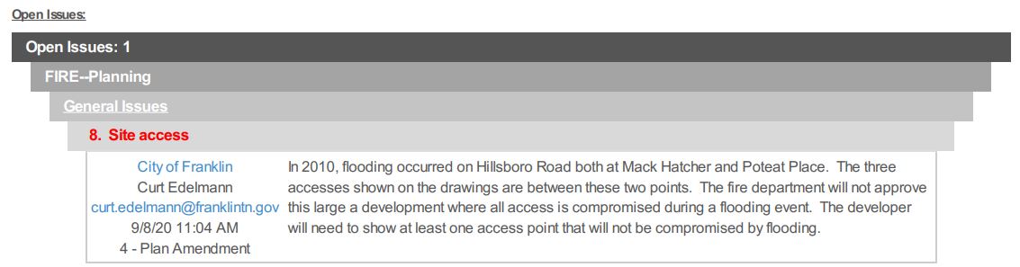
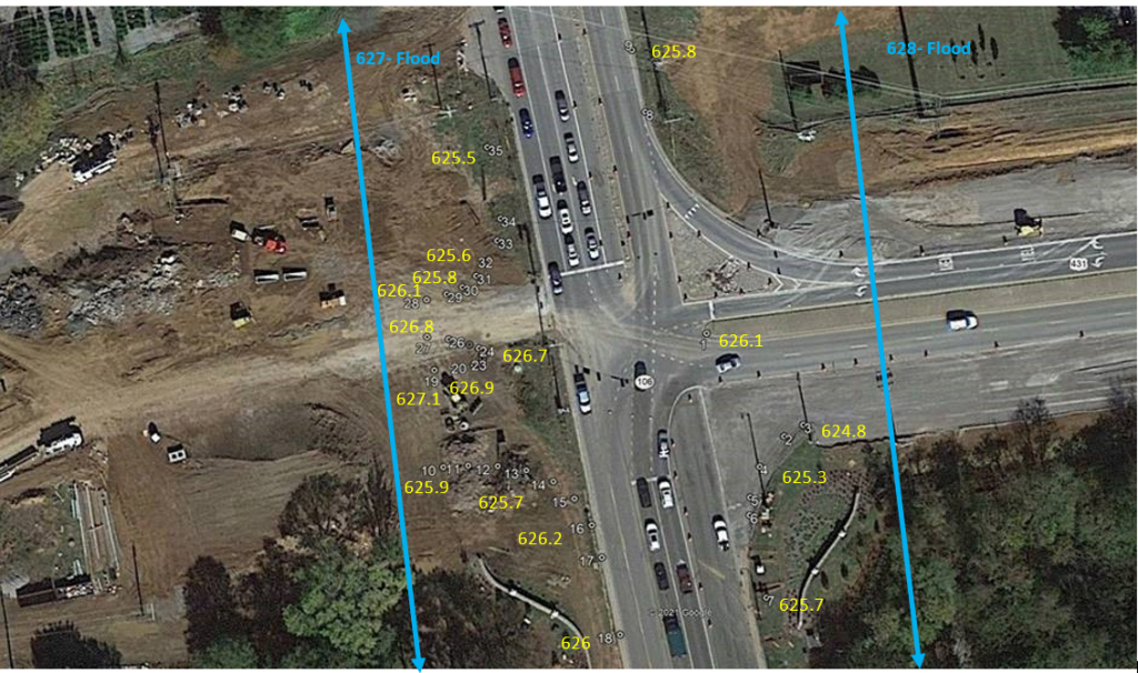
The city staff elevated a major concern with floodwater depths on Hillsboro Road that are over 1 to 2.5 feet and highlighted city requirements that the development proposal did not meet. (see staff memo) The staff provided two detailed maps prepared by city outside consultants. City Fire department stated in 2020 that it would not approve this high-density residential proposal because all accesses were compromised by floodwaters.
The map below was prepared by the city outside engineering expert that shows detailed floodwater depths. This detail corroborates the data compiled by Harpeth Conservancy from readily available FEMA data and from TDOT’s contractor that recently completed the section of Mack Hatcher (provided at the end of this blog). Click here for the second map the city had prepared with details on depth of flood waters along Hillsboro Road between the Harpeth river bridge crossing to Mack Hatcher parkway.
One of the city’s stormwater and flood management requirements is for emergency vehicles to have emergency access to the development that by-passes 100-year flood waters. This important issue had not been addressed by the developer up until the last meeting. Click here for the possible emergency vehicle path around high floodwaters along Hillsboro Road through the landscaping company property. This proposal requires elevating a road out of the floodplain, further flood model work, and property owner agreement. There is little detail as to whether this is viable.
The second key issue is that the city’s floodplain management requirements state that critical service roads, such as Hillsboro Road, not have floodwater depths over 3 inches across half the road at the 100-year floodplain for new development. The development proposal’s fatal flaw is that it does not reduce the public safety risk from flooding on Hillsboro Road.
Recent press in September 2021: Franklin Home page, Williamson Herald, Tennessean, Williamson Source
Press after October 2021 meeting: Franklin Home Page, Williamson Source, Williamson Herald
1. Public safety issue with floodwaters on existing roads
- At 1 to 4 feet deep (see map above), floodwaters on all existing roads are significantly ABOVE the city requirements that new development provides an emergency bypass for a 100-year flood and that existing and critical service roads not have more than 3 inches of floodwaters over more than half the road. (Section 23-106 (2) implementation, (e) stormwater design requirements p. 13). City Fire Department in Sept 2020 said it “will not approve this large development where all access is compromised during a flooding event.” (See below for FEMA maps and elevation information.)
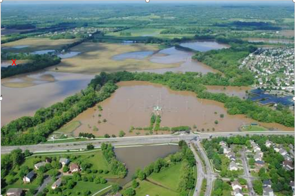
- NOAA Nashville Weather Service Flood Safety information– Turn Around Don’t Drown- states that 6 inches will reach the bottom of most passenger vehicles and cause loss of control or stalling. A foot of floodwater will float most vehicles. 2 feet of rushing water will can carry away most vehicles. Public safety is a major concern for a high residential subdivision on this area of the Harpeth that has 1 to 4 feet of floodwaters on all roads in and out.
- For a floodplain and floodway fill proposal like this (see map above) to go to FEMA for the required review, the city completes a form that states that the proposal meets all city floodplain management requirements. This proposal does not meet all the city’s floodplain management requirements because of the high floodwater depths on Hillsboro Road.
2. The floodplain alteration is extensive and directly conflicts with the city’s Envision Franklin Plan
- As city staff stated in the recommendations to deny both the rezoning and development plan, the Envision Franklin land use plan specifically states “the preservation of floodplains has a direct public safety purpose and helps to minimize property damage during flooding. Disruption should be limited to preserve form and function.”
- The proposal does NOT “improve” the Harpeth’s natural floodplain as the developer stated, but alters it significantly. The extensive alteration involves extensive excavation, known as a “cut”, 6-10 feet over many acres, and down 24 feet to build a pond, to provide dirt to build up, known as “fill,” over 50 acres. This removes most of the shallow areas that provide a critical function of slowing floodwaters down. 70% of the residential units are in this filled area of the floodplain! See staff memo.
- The floodplain and floodway fill proposed maximizes buildable land on the property. It does not “improve” any flooding risk on Hillsboro Road nor for residential areas across the river from Brownland or just downriver, that now have residences in the 100-year floodplain. (See staff memo from 9/7/2021 explaining how floodplain plan maximizes proposed development but does not improve any flooding issues off site.)
3. Flooding risks are increasing in this region of the country
- Rainstorms are increasing in intensity and frequency as witnessed in the Nashville and Franklin area in March and most recently with catastrophic flooding in Waverly and nearby areas. The top 1% of rainiest days have increased 18% over the last 30 years! Tennessee has the highest rate of severe tornado generating storms at night, as reported in Tennessean. This increases the risk of death in this region from severe storms.
Press story 3/27/2022- Need to Update Severe Storm Statistics: Tennessean. HC CEO and other floodplain management experts quoted.
- Floodplain lines on a map are probabilities. They are not hard and fast features on the land like a wall or sidewalk. Floodplain lines are based on statistics that are now recognized by experts to be UNDERESTIMATING the amount of rainfall and storm intensity. See our Conservation Conversation with experts on why flooding is increasing in this area of the country, and our blog on the Flood Factor national study that provides a user-friendly portal that presents the risk to individual properties.
- Franklin and Nashville have many development requirements beyond FEMA’s minimum requirements. But staff have highlighted the need to review how to update these to account for the increased storms to prevent flood damage and minimize risks to public safety.
Click here for Harpeth Conservancy analysis and comments to Planning Commission, Aldermen and staff on August 2020 and July 2021
Full set of October 2021 development proposal including city staff memos explaining reasons to recommend denial of the zoning and development plan. pages 40-196. Includes Christ Community Church.
Floodwater Depths on Roads that Provide only way in and out of Brownland Farm/Christ Community Church Development proposal: (Data from FEMA, TDOT)
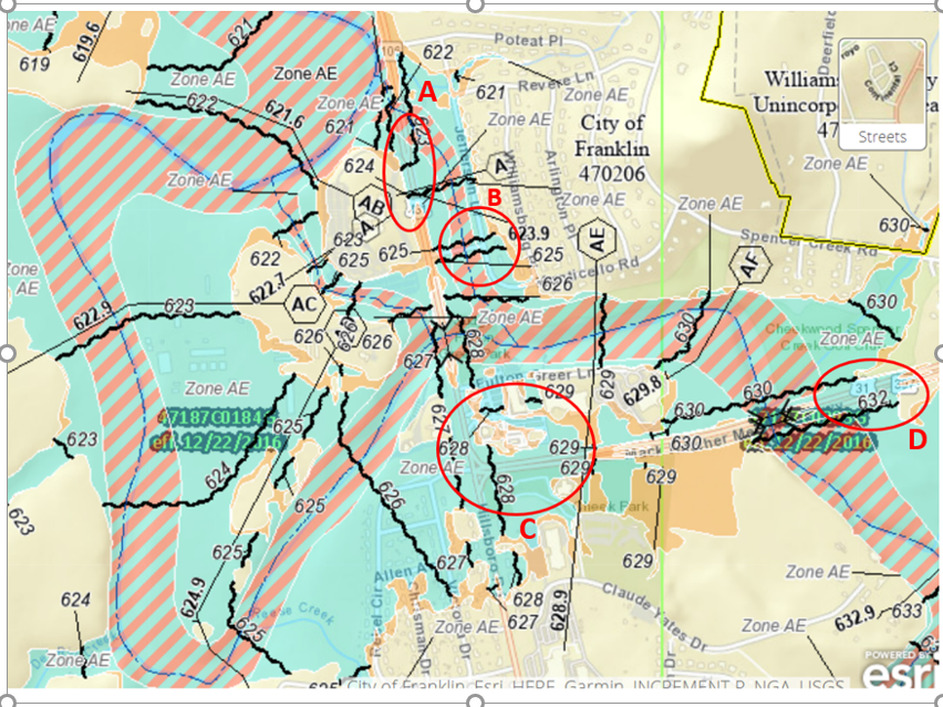
A: Hillsboro Road- 1 foot deep.
B: Monticello Road—4.5 feet deep
Data for both locations- Flood Insurance Study, 2/26/21. (Harpeth River East Split Flood profile– Vol 3, p. 72)
C: Mack Hatcher Parkway and Hillsboro Road: Close to 2 feet in middle of intersection.
West of intersection where Mack Hatcher is almost complete: 1.5 feet to 0.1 feet as measurements go west of Hillsboro road along the new curb up the slope.
East of Intersection: 3.2- 2.2 feet deep.
Click for Elevations around Mack Hatcher intersection from Eutaw.
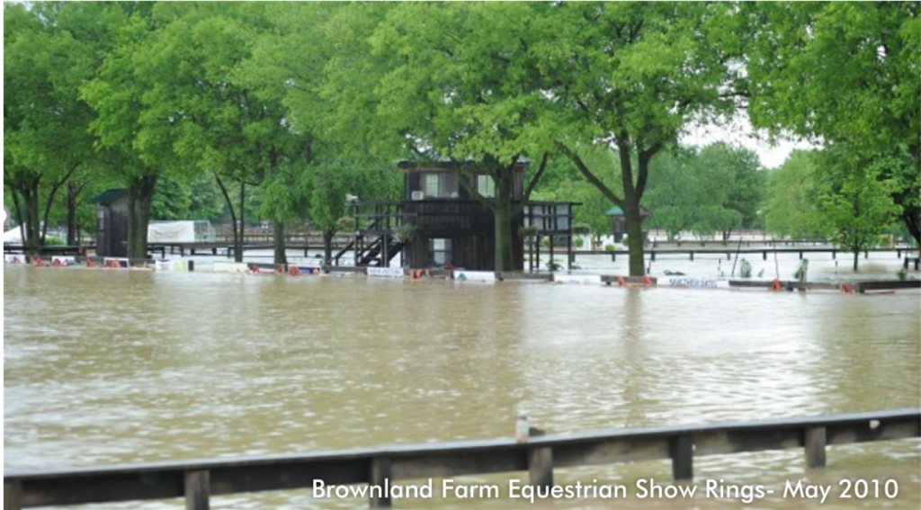
For more flooding photographs of the area see first blog on Brownland Farm development proposal.